|
Fort
de Chartres
The
French
On
January 1, 1718, the
French government
granted a trade
monopoly to John Law
and his 'Company of
the West'. Hoping to
make a fortune
mining precious
metals, the company
built a fort to
protect its
interests. The
original wooden fort
was built in
1718-1720 by a
French contingent
from New Orleans led
by Pierre Dugu�
de Boisbriand. When
administration of
the Illinois Country
was moved from
Canada to New
Orleans, governance
was transferred to
the Company of the
Indies. The fort was
built to be the seat
of government and to
control the Indians
of the region,
particularly the
Fox. The original
fort was a palisade
of logs with two
bastions at opposite
corners.
|
|
Within
five years,
flooding
from the
Mississippi
had left the
original
fort in bad
condition.
Construction
of a second
fort further
from the
river, but
still on the
flood plain,
began in
1725. This
fort was
also made of
logs and had
a bastion at
each of the
four
corners. By
1731 the
Company of
the Indies
had gone
defunct and
returned
Louisiana
and its
government
back to the
king. |
The
second wooden fort
deteriorated
somewhat less
rapidly but by 1742
was in bad repair.
In 1747 the French
garrison moved to
the region's primary
settlement 18 miles
(29 km) to the south
at Kaskaskia. The
French debated where
to rebuild the fort.
When rule of the
area reverted to the
French crown in the
1730s, officials
began to discuss
construction of a
stone fortress. The
government in New
Orleans wanted to
move the garrison
permanently to
Kaskaskia, but the
local commandant
argued for a
location near the
original site.
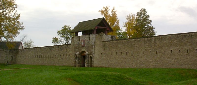
The
government decided
to rebuild a fort in
stone near the first
forts rather than at
Kaskakia.
Construction began
in 1753 and was
mostly completed in
1756; however,
construction
continued at the
site for another
four years. The
limestone fort had
walls 15-ft (3
m)-high and 3-ft
(1m)-thick,
enclosing an area of
4 acres (16,000 m�).
The stone for
construction was
quarried in bluffs
about two or three
miles (4 km) distant
and had to be
ferried across a
small lake.
The
British
In
1763 the Treaty of
Paris was signed
following the Seven
Year War (French
& Indian War)
and the French
transferred control
of the Illinois
Country to Great
Britain. The stone
fort had served as
center of French
administration of
the region for only
ten years. With the
Royal Proclamation
of 1763, the British
Crown declared
almost all of the
land between the
Appalachian
Mountains and the
Mississippi River
from Florida to
Newfoundland an
Indian Reserve.
|
|
The
British had
difficulty
getting a
regiment to
their newly
acquired
fort, but on
October 10,
1765, a
small
detachment
of the 42nd
Royal
Highland
Regiment
took control
of the fort
and
surrounding
area. The
42nd was
shortly
replaced by
the 34th
Regiment.
French
settlers
were ordered
to leave or
get a
special
license to
remain. Many
French
settlers
moved to the
more
congenial
culture of
St. Louis.
The 34th
Regiment of
Foot renamed
the
installation
Fort
Cavendish,
after its
colonel. |
However,
the post was known
as Ft. Chartres from
1768 on, after the
34th were replaced
by the 18th (Royal
Irish) Regiment
under the command of
Lt. Col. Wilkins.
The British,
abandoned the post
in May 1772 when the
majority of the 18th
(Royal Irish)
Regiment was ordered
back to
Philadelphia. A
small party under
Capt Hugh Lord
remained at
Kaskaskia until May
1776.
Ruin
|
The
Mississippi
continued to
take its
toll after
the fort was
abandoned.
In 1772 the
south wall
and bastion
fell into
the river.
The
remaining
walls
deteriorated,
and visitors
noted trees
growing in
them by the
1820s.
Locals
carted away
stones for
construction
over the
years. By
1900 the
walls were
gone. The
only part of
the original
fort that
remained was
the stone
building
that had
served as
the powder
magazine.
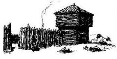
|
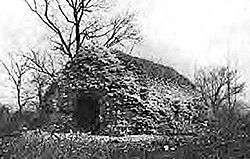
The
fort's
powder
magazine
prior to
restoration.
|
Reconstruction
|
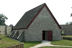
The
fort's
powder
magazine,
here
restored, is
thought to
be the
oldest
standing
building in
Illinois.
|
The
State of
Illinois
acquired the
ruins in
1913 as a
historic
site and
restored the
powder
magazine in
1917. The
powder
magazine is
thought to
be the
oldest
existing
building in
the state of
Illinois. In
the 1920s
foundations
of the
fort's
buildings
and walls
were
exposed. In
the late
1920s and
through the
1930s, the
US WPA
rebuilt the
gateway and
two stone
buildings. |
A
combination museum
and office building,
constructed in 1928
on the foundation of
an original fort
building, houses
exhibits depicting
French life at Fort
de Chartres. The
large stone
�Guards House,�
reconstructed in
1936, contains a
Catholic chapel
furnished in the
style of the 1750s,
along with a
priest�s room, a
gunner�s room, an
officer-of-the-day
room, and a
guard�s room. Also
on the grounds are
an operating bake
oven, a garden shed
built of upright
logs in French
Colonial poteaux-sur-solle
(French: post on
sill) construction,
and a kitchen garden
with raised beds of
produce typical of
French 18th-century
Illinois.
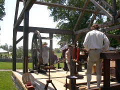
Partial
reconstruction of
the fort's walls on
the original
foundations followed
in 1989. The frames
of some additional
buildings were
erected as a display
of the post-and-beam
construction
techniques used for
the originals. Other
buildings'
foundations and
cellars were exposed
for educational
display as well.
Today
the site has a
museum and small
gift shop. It plays
host each June to a
Rendezvous that is
said to be one of
the largest and
oldest in the
country celebrating
frontier French and
Indian culture.
The
site is protected by
modern levees, but
the Mississippi
River is still an
occasional menace.
______________________________________________________________
The
flood of 1993
breached the levee
and sent waters
fifteen feet deep to
lap at the top of
the walls.
|

Missouri
River,
supper time.
 The
flood of '93
was
something to
see and an
event we
wouldn't
forget.
The
flood of '93
was
something to
see and an
event we
wouldn't
forget.
|
A
small group
of us (11)
experienced
this flood
traveling
from Bonnets
Mill MO to
Fort de
Chartres IL
for their
'93
rendezvous.
Don't let
anyone tell
you a
refrigerator
won't float
(we had one
pass us in
seven knot
water)
that's fast
believe me.
Merchandise
from washed
out
businesses
was
everywhere.
A half dozen
basket balls
came by, we
couldn't let
that happen
- the
flintlocks
took care of
the problem.
Talk about
'white
knuckles'.....
Nothing like
a 40' tree
coming
within 20'
of your
canoe and
your
thinking 'a
limb is
going to
tear the
bottom out
of us'.

Neat
spot on the
Missouri
near
Washington
MO.
Thinking
back we were
very lucky
having no
major issues
and having
God's
blessing
with
us.
|
______________________________________________________________
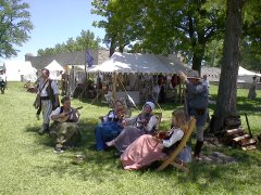
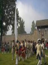
Rendezvous
Each
June, Fort de
Chartres State
Historic Site hosts
the largest
rendezvous in the
Midwest with over a
thousand
participants,
hundreds of
encampments, and
thousands of
visitors joining in
on the festivities.
Based on the
traditional French
fur trapper�s
rendezvous where
trappers and traders
would meet at a
predetermined
location to trade
furs for
necessities, the
rendezvous was the
highlight of the fur
trapper�s year and
is the highlight of
Fort de Chartre�s
extensive calendar
of historical events
and activities.
|
The
Annual
Rendezvous
at Fort de
Chartres
offers
participants
and visitors
alike a
glimpse into
the period
from
1740-1840, a
part of
Illinois�
past when it
was governed
not only by
France but
by Great
Britain and
the United
States as
well.
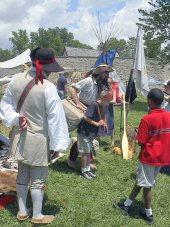
Costumed
reenactors
portray a
variety of
personas
including
colonial
military
units,
mountain
men, Native
Americans,
settlers,
merchants,
and more.
Historical
demonstrations
are located
at various
locations on
the grounds
and there
are periodic
demonstrations
that include
period
music,
military
drills, and
musket and
cannon
competitions.
|
|
|
|
As
Fort de
Chartres is
an Illinois
Historic
Preservation
Agency site,
there is a
wide variety
of
interpretive
activities
that can be
found
throughout
the grounds.
These
activities
run
continuously
throughout
both days.
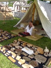
In the
Native
Crafts area,
visitors can
learn first
hand the
arts of bow
and arrow
making, hide
tanning,
basket
weaving, the
use of
native foods
and herbs,
pottery, the
construction
of wigwams,
and the
history of
how and why
the fur
trade became
such an
important
frontier
industry.
There are
also archery
demonstrations
and
competitions. |
______________________________________________________________
|

Talk
about being
eerie ...
damn fog ...

Are
we there yet
....

We're
dragging
bottom again
....
|

There's
a BARGE
COMING AT US
....
We
would run
into some
unusual
traffic from
time to
time. These
river men
would have a
great time
talking to
us. 'What
are you
guys,
pirates, are
you fuc...g
frogs ?' (French)...
But
they always
had funny
remarks and
willing to
share their
comments.
There
was a flood
in '93 on
the
Mississippi
River but in
our passage
we
experienced
water
shortages on
the Platte
and Missouri
Rivers.
What
do you do
now? Simple
get out and
pull your
equipage and
canoe. The
one I'm
pulling is
22' long and
has close to
600 lbs of
food,
clothing,
cook ware
and misc.
camp items
plus the
weight of
the canoe
for this 28
day trip.
With this
much gear
and (3) 200
lb. guys it
is a load to
handle.
_____________________
|
|
The
Colonial
Area
features
demonstrations
that include
spinning,
dyeing, the
use of
looms,
woodworking,
weaving,
quilting,
rope making,
coopering,
and
blacksmiths.
Located in
the Fort
buildings
themselves
are a French
Patron
(River
Boatman,) a
French
Marines
quarters, a
Jesuit
missionary
in the
Fort's
Chapel, and
the
Piethman
Museum
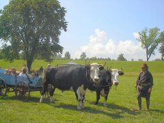
. A French
Colonial
garden,
oxen, and
baked goods
for sale
from a
working
stone oven
can be found
near the
demonstration
areas.
Throughout
the grounds
are
demonstrations
by
independent
merchants
illustrating
their
skills, and
displaying
and selling
their
creations.
|
|
|
|
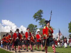
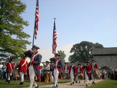
Fort
de Chartres
began as a
French
military
outpost. The
reconstructed
stone fort
represents
the third
fort built
by the
French, the
first two
wooden forts
having been
destroyed by
the
Mississippi
River
. It was
this stone
fort that
the French
turned over
to the
British in
1765 after
the end of
the French
and Indian
War. The
British
abandoned
this fort,
moving their
territorial
headquarters
to the
nearby town
of
Kaskaskia
. The
abandoned
stone fort
was visited
by George
Rogers Clark
during his
expedition
during the
Revolutionary
War.
Representing
this
military
tradition
are a number
of military
reenactment
units and
marching
bands
representing
all three
colonial
powers.
Rifle,
musket, and
artillery
competitions
are all part
of the
scheduled
programs. |
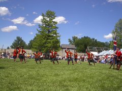
Period
music can be found
at any time during
the event. A center
stage is set up
within the fort and
features various
musical groups
throughout the day.
Many of these groups
can be found
entertaining
visitors throughout
the grounds when
they are not
featured on the main
stage. In addition
marching military
bands with drums,
flutes, bagpipes,
and other
instruments can be
seen patrolling the
grounds.
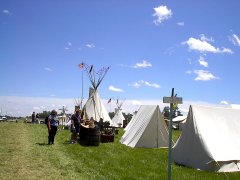
Hundreds of tents,
teepees, and other
primitive shelters
become the weekend
home for the over
one thousand
reenactors who come
to Fort de Chartres
from across the
country. Visitors
can gain a lot of
insight into the
life styles of the
fur trapping era by
exploring the
Primitive Camp. The
reenactors are a
friendly bunch and
are happy to talk
about the specifics
of their camp and
the personas they
portray. Sutlers,
merchants, and trade
blankets are located
throughout the
grounds selling many
period related goods
that are only
available at this
type of event.
Information
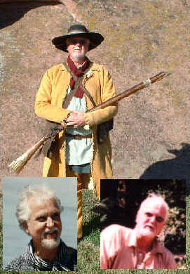
from Fort de Chartres State Historical Website.
Directions
to the fort
|

|
Directions:
Fort de
Chartres
State
Historic
Site is
located 4
miles west
of Prairie
du Rocher,
about an
hours
drive
south of
St. Louis
. Take
IL-3 to
Ruma and
then turn
west on
IL-155.
Follow
IL-155
through
Prairie du
Rocher to
the site.
For
more
information
call
618-284-7230.
|
|